
"Millions of years ago when the glaciers melted, before anything had a name, the island lay sheltered in an estuary." For thousands of years, the Lenape people lived on the island of Mannahatta, "using what they needed and nothing more." In 1609, Englishman Henry Hudson saw the island and told his Dutch employer about the land; the Dutch then claimed its southern port as their own.
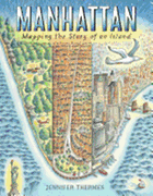
So begins Jennifer Thermes's (Charles Darwin's Around-the-World Adventure) picture book history of New York City, Manhattan: Mapping the Story of an Island. Thermes gives readers a fascinating account of New York City's development from the time of the Lenape people to the present day, including information about the American Revolution, city planning, the Great Fire of 1835 and more, right up through Hurricane Sandy and "Manhattan Today." In addition to her historical text about "the city on the island," she uses sidebars, speech bubbles and notes incorporated directly into the illustrations to give supplemental information. An example: an illustration of Manhattan in the late 1700s sits on the same page as text that says it was a "time of industry, growth, and freedom. (But not for everyone.)"; an illustrated sidebar points out that "slavery continued in New York City after the American Revolution" and that "the city was rebuilt using slave labor and immigrants." Thermes's dynamic watercolor, colored pencil and ink illustrations tell as much of the story as the text, showing New York City's expansion in great detail.
Manhattan, with tons of backmatter and fun paratextual material, uses every part of the book--front cover all the way to the final endpapers--to give young readers an in-depth and entertaining history of the city on the island. --Siân Gaetano, children's and YA editor, Shelf Awareness